Every block you hold, and what it could become.

Talk to us Watch demo

An animated illustration of two message threads, played in turn and then again. First, the chairperson asks before Thursday's meeting what is stopping the council from building homes on Creek flats. The land officer replies 'Pulling it up now.' Tend Land opens over the conversation: a drawn map shows the council's blocks shaded by housing score, a 1-in-100-year flood band spreads along the creek over the low side of Creek flats, and the block's assessment opens with flood circled as its lowest score, 2, and housing at 3 of 5, Moderate. The assessment shrinks into the reply: flood is the block's lowest score, zoning and bushfire are fine, and the summary is in the board papers. The chairperson thanks the officer. Second, the chairperson asks which block is the best bet for new homes for community. Tend Land's list of blocks opens, sorted by most recent; the sort is changed to housing prospect, highest first, and the rows move into order: Ridge Road block 5, Strong; South paddock 4, Good; Creek flats 3, Moderate; Mill Street 2, Constrained. The top block is opened: the map finds it, then its assessment shows housing 5 of 5, Strong, zoned for homes and clear of flood and bushfire. The assessment shrinks into the reply, and the chairperson asks to put Ridge Road on Thursday's agenda.

1 of 5

Every block you hold, on one map.

Each block is tracked from the day it's offered to the day it's registered.

  1. Offered
  2. Under review
  3. Accepted
  4. Transfer in progress
  5. Registered

Zoning, flood and bushfire come from NSW government records, and your team checks each one. Not every council area has flood mapping yet.

Map screen: waiting on the map provider's permission.

A block's card in Tend Land: South paddock, Gulgong, 40,448 square metres, registered, with a housing prospect of Good, and a link to open the parcel's record.

2 of 5

The papers stay with the block.

Upload the title searches and plans you hold, and Tend Land files each against its block, not in a box.

  • When people move on, the record stays with the block
  • A missing paper says so

South paddock's documents: a title search and a survey plan filed against the block, each with an Open link, and a rates notice marked Missing, not held yet, circled in gold.

3 of 5

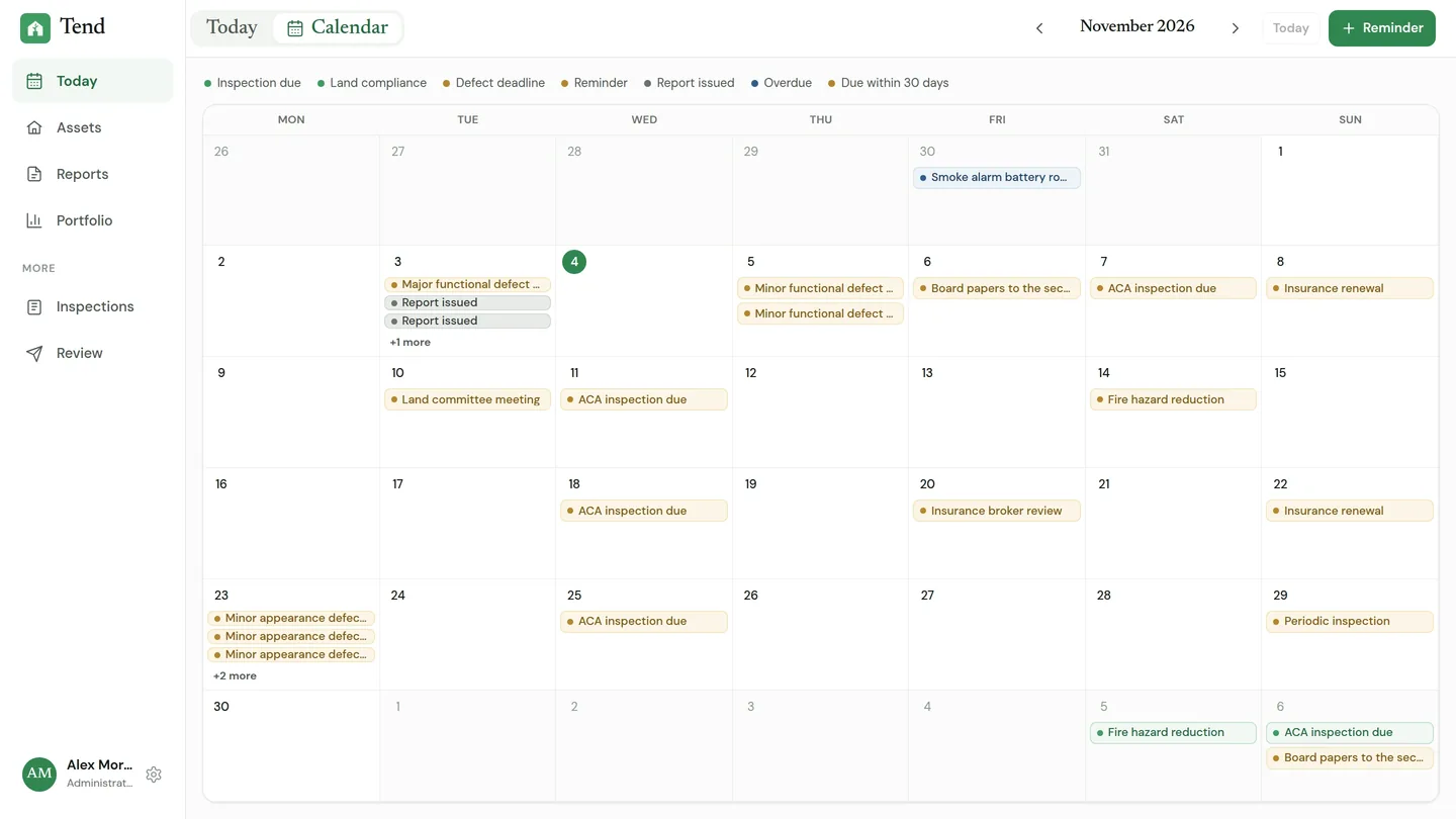
Insurance, rates and hazard reduction, all in view.

Each has a due date on the block it belongs to. Tend shows what's overdue, and what's coming.

Tend's calendar for November 2026, with an insurance renewal on the 8th, a land committee meeting on the 10th and fire hazard reduction on the 14th circled in gold, beside the housing dates on the same calendar.

See the real screen

4 of 5

Each block, scored for housing and community use.

Scored 1 to 5 for housing and for community facilities, on the same measures for every block, each with its basis and source.

  • Size
  • Zoning
  • Planning pathway
  • Flood
  • Bushfire
  • Social need (ABS Census)
  • A layer that isn't mapped is left out, never counted as clear
  • Every block side by side, on one page for the board
  • Keep it, protect it or build on it: your board decides

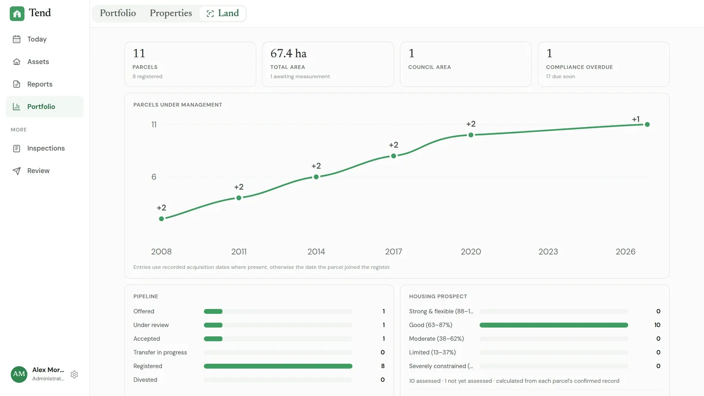
The Tend Land portfolio: 11 parcels, 8 of them registered, covering 67.4 hectares, with 1 compliance item overdue, circled in gold. A line shows parcels under management growing from 2008 to 2026, and a pipeline runs from offered to registered.

See the real screen

5 of 5

Your team keeps the record. Your board reads it.

Invite your team, and give your board its own read-only view.

  • Private to your organisation. Your records aren't visible to any other organisation.
  • Hosted in Australia. The records, papers and their backups are kept in Australian regions.

Talk to us about your land.

Priced with each Land Council. Tell us roughly how many blocks you hold.

Talk to us Watch demo